The Manitoba Wildfire Service advises the majority of the province continues to be at a high and extreme fire danger level and anticipates challenging conditions as existing fires continue to grow.
Manitoba Parks advises the southern portion of Atikaki Provincial Park is closed effective 5 p.m. today, including the Bloodvein and Gammon river corridors and Aikens Lake. All park users must vacate the area. For updates on park closures, visit www.manitobaparks.com.
While fire and travel restrictions have been lifted for most of the province, travel permits are required within active fire boundaries. To view active fire boundary maps, visit: www.gov.mb.ca/conservation_fire/Fire-Maps/fireview/fireview_map.html. To apply for a travel permit, contact a Natural Resources and Indigenous Futures district office and visit: www.gov.mb.ca/nrnd/co/index.html to find a location.
Fires of note
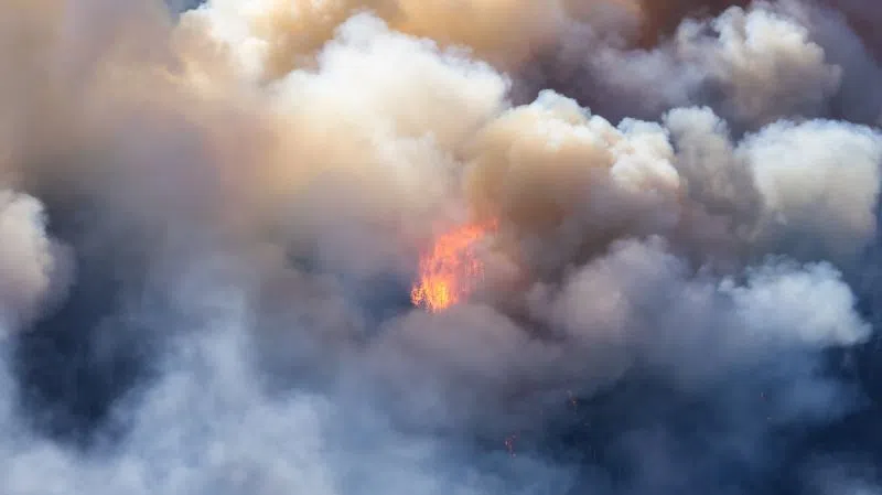
The Manitoba Wildfire Service continues to respond to 98 active wildfires across the province, a total of 252 wildfires to date, well above the average for this date of 194 total fires.
Fires of note include:
East region:
- Fire EA061 remains out of control at approximately 234,390 ha. Provincial Road (PR) 315 is open with access to Bird Lake, Booster Lake, Flanders Lake and Davidson Lake. A closure and mandatory evacuation order continues for parts of Nopiming Provincial Park and the entire areas of Wallace Lake and South Atikaki provincial parks. PR 314 remains closed through Nopiming Provincial Park.
West region:
- Fire WE017, located near Sherridon and the city of Flin Flon, is approximately 370,780 ha and is out of control. For the safety of personnel, boaters are asked to avoid waterways being utilized by Manitoba Wildfire Service tankers and aircraft.
- Fire WE025, located near Mathias Colomb Cree Nation (Pukatawagan), is approximately 59,220 ha and is being monitored. The fire is contained around the community but a mandatory evacuation order continues.
- Fire WE028, located 10 kilometres (km) from Bakers Narrows Provincial Park, is approximately 7,200 ha and is out of control.
- Fire WE052, located 24 km from Snow Lake, is approximately 3,000 ha and is out of control.
- Fire WE053, located 16 km from Snow Lake, is approximately 1,760 ha and is out of control.
- Fire WE059, located 12 km from Snow Lake, is approximately four ha and is under control.
North region:
- Fire NO002, located near the town of Lynn Lake, is approximately 80,120 ha and is out of control.
- Fire NO042, located 14 km southwest from the town of Lynn Lake, is approximately 9,525 ha and is out of control. A mandatory evacuation order is in place for the town of Lynn Lake.
- Fire NO005, located near Pimicikamak Cree Nation (Cross Lake), the Incorporated Community of Cross Lake, Jenpeg Generating Station and Whiskey Jack Landing, is approximately 80,080 ha and is out of control.
- Fire NO055, located 12 km from Pimicikamak Cree Nation (Cross Lake), is approximately 3,000 ha and is out of control.
- Fire NO010, located near Tataskweyak Cree Nation (Split Lake), is approximately 22,275 ha and is being held. A mandatory evacuation order remains in place for Tataskweyak Cree Nation (Split Lake).
- Fire NO026, located 14 km from the town of Leaf Rapids, is approximately 6,820 ha and is out of control. A mandatory evacuation order is in place for the town of Leaf Rapids.
- Fire NO047, located 26 km from Leaf Rapids, is approximately 7,015 ha and is out of control.
- Fire NO061, located 14 km from Thompson, is approximately 5,900 ha and is out of control.
- Fire NO076, located seven km from Wabowden, is approximately 44 ha and is out of control.
- Fire NO079/82, located near Kistiganwacheeng (Garden Hill First Nation), is approximately 52 ha and is out of control.
Information and resources for evacuees
Evacuees requiring assistance are reminded to go to Winnipeg. The primary evacuation reception centre for all evacuees is the Leila Soccer Complex at 770 Leila Ave.
Visit MBReady at https://mbready.manitoba.ca for more information about emergency alerts and safety, as well as resources for evacuees such as:
- registering with the Canadian Red Cross: https://gov.mb.ca/wildfire/evacuees.html#wildfire-2025
- financial support: https://gov.mb.ca/wildfire/evacuees.html#financial-support
- emergency shelters: https://gov.mb.ca/wildfire/evacuees.html#shelter
- health resources: https://gov.mb.ca/wildfire/evacuees.html#health-resources
- insurance: https://gov.mb.ca/wildfire/evacuees.html#insurance
- returning home: https://manitoba.ca/wildfire/evacuees.html#community-re-entry
All Manitobans returning to reopened areas are advised to be prepared to evacuate again with little notice and should prepare an emergency go kit. More information on emergency preparedness, including what to include in an emergency go kit, is available at www.gov.mb.ca/emo/guide/individuals.
For assistance, evacuees can dial Manitoba 211 from anywhere in Manitoba or email 211mb@findhelp.ca. For more information, visit https://mb.211.ca/get-help-now/.